
Oxfordshire County Map-Paper
Oxfordshire County Map-Paper

Overall Rating: 2.4 / 5 (average from multiple review sources, as of 9 Jan 2026)
Based on a total of 45,295 customer reviews from independent review platforms.
Sources & Transparency:
The values are derived from publicly available retailer ratings from platforms such as Feefo, http://Reviews.io , Trustpilot, and others, and are aggregated monthly.
All brand names and logos are the property of their respective owners.
Notice:
pricehunter.co.uk cannot guarantee that published shop ratings originate from consumers who have actually made a purchase from the reviewed retailer.
Cheapest Total Price
In stock. Express Delivery available with Amazon Prime.
Direct debit
Direct debit
Visa
Visa
Mastercard
Mastercard
£27.99
Free Delivery
Oxfordshire County Map-Paper

In stock
Direct debit
Direct debit
Visa
Visa
Mastercard
Mastercard
£28.99
Free Delivery
🤖 Ask ChatGPT
💡 Is it worth the price?
🔁 Better alternatives?
⭐ What do users say?
Oxfordshire County Map-Paper - Details
▶ Finding you the best price!
We have found 2 prices for Oxfordshire County Map-Paper. Our price list is completely transparent with the cheapest listed first. Additional delivery costs may apply.
Oxfordshire County Map-Paper - Price Information
- Cheapest price: £27.99
- The cheapest price is offered by amazon.co.uk . You can order the product there.
- The price range for the product Oxfordshire County Map-Paper is €£27.99to €£28.99 with a total of 2 offers.
- Payment methods: The online shop amazon.co.uk supports: Direct debit, Visa, Mastercard
- Delivery: The shortest delivery time is In stock. Express Delivery available with Amazon Prime. working days offered by amazon.co.uk .
Similar products
Oxfordshire County Map, Thomas Moule Oxfordshire Map,
£9.00
Amazon-marketplace.co.uk
Free Delivery

A Oxfordshire 1611 - 1836 - Fold Up Map that features a collection of Four Historic Maps, John Speed's County Map 1611, Johan Blaeu's County Map of 1648, Thomas Moules County Map of 1836 and a Plan of
£18.39
Whsmith.co.uk
Delivery from £3.99
Oxfordshire County Map-Plastic Coated
£29.99
Amazon-marketplace.co.uk
Free Delivery

Exceptional Art c.1806 County Maps of England - Round - 96 x 96cm - Black - Oxfordshire
£339.99
rackhams.com
Free Delivery

Akachafactory Sticker car flag map country province region county oxfordshire
£2.60
Amazon-marketplace.co.uk
Delivery from £2.75
Cheapest offer
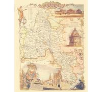
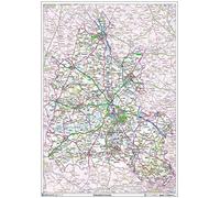
Striking wall map showing the ceremonial county, ceremonial counties are areas of England to which lord-lieutenants are appointed. This county map shows the ceremonial boundary overlaid on a clear and easy to read Ordnance Survey map, with the ceremonial county area highlighted, the region outside the boundary faded out with a subtle tint. 120 gsm Art Quality Paper A0 - 1189mm x 841mm
£27.99
In stock. Express Delivery available with Amazon Prime.
amazon.co.uk
Don't forget your voucher code:
Report Illegal Concerns
You are about to report a violation based on the EU Digital Services Act (DSA).