
UK White Postcode Areas Wall Map - A1 Size 594mm x 841mm - England, Scotland & Wales - Clean White Design - 120gsm Art Paper - Ideal for Office, Classroom & Home Study
UK White Postcode Areas Wall Map - A1 Size 594mm x 841mm - England, Scotland & Wales - Clean White Design - 120gsm Art Paper - Ideal for Office, Classroom & Home Study

Overall Rating: 1.4 / 5 (average from multiple review sources, as of 12 Jun 2026)
Based on a total of 63 customer reviews from independent review platforms.
Sources & Transparency:
The values are derived from publicly available retailer ratings from platforms such as Feefo, http://Reviews.io , Trustpilot, and others, and are aggregated monthly.
All brand names and logos are the property of their respective owners.
Notice:
pricehunter.co.uk cannot guarantee that published shop ratings originate from consumers who have actually made a purchase from the reviewed retailer.
Cheapest Total Price
In stock
Direct debit
Direct debit
Visa
Visa
Mastercard
Mastercard
£24.99
Free Delivery
UK White Postcode Areas Wall Map - A1 Size 594mm x 841mm - England, Scotland & Wales - Clean White Design - 120gsm Art Paper - Ideal for Office, Classroom & Home Study
Overall Rating: 1.4 / 5 (average from multiple review sources, as of 12 Jun 2026)
Based on a total of 63 customer reviews from independent review platforms.
Sources & Transparency:
The values are derived from publicly available retailer ratings from platforms such as Feefo, http://Reviews.io , Trustpilot, and others, and are aggregated monthly.
All brand names and logos are the property of their respective owners.
Notice:
pricehunter.co.uk cannot guarantee that published shop ratings originate from consumers who have actually made a purchase from the reviewed retailer.
Based on a total of 63 customer reviews from independent review platforms.
Sources & Transparency:
The values are derived from publicly available retailer ratings from platforms such as Feefo, http://Reviews.io , Trustpilot, and others, and are aggregated monthly.
All brand names and logos are the property of their respective owners.
Notice:
pricehunter.co.uk cannot guarantee that published shop ratings originate from consumers who have actually made a purchase from the reviewed retailer.
Usually dispatched within 2 to 3 days
Direct debit
Direct debit
Visa
Visa
Mastercard
Mastercard
£31.99
Delivery from £7.69
Cheapest offer
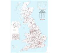
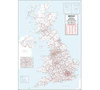
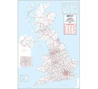
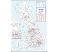
POSTCODE OVERVIEW: This UK white postcode areas wall map clearly displays postcode regions across England, Scotland, and Wales. Designed with a clean white background, it makes postcode boundaries and labels easy to identify for planning, learning, and everyday reference. A1 WALL SIZE: Printed at A1 size 594mm x 841mm, this medium-format wall map offers excellent readability while fitting comfortably into smaller offices, classrooms, home studies, or workspaces without overwhelming the wall. UK COVERAGE: Focusing specifically on UK postcode areas, this map helps users quickly understand postal geography across the country. Ideal for business planning, sales territories, delivery zones, education, and general postcode reference. ART PAPER: Printed on high-quality 120 GSM art paper, the map delivers sharp detail and a clean, professional appearance. Suitable for framing, pinboards, or wall mounting, it is designed for indoor display and long-term use. EVERYDAY USE: Perfect for students, teachers, professionals, and home users, this postcode wall map supports learning, organisation, and planning. The minimalist white design also works well as functional wall décor in professional and educational spaces.
£24.99
In stock
Amazon-marketplace.co.uk
🤖 Ask ChatGPT
💡 Is it worth the price?
🔁 Better alternatives?
⭐ What do users say?
UK White Postcode Areas Wall Map - A1 Size 594mm x 841mm - England, Scotland & Wales - Clean White Design - 120gsm Art Paper - Ideal for Office, Classroom & Home Study - Details
▶ Finding you the best price!
We have found 2 prices for UK White Postcode Areas Wall Map - A1 Size 594mm x 841mm - England, Scotland & Wales - Clean White Design - 120gsm Art Paper - Ideal for Office, Classroom & Home Study. Our price list is completely transparent with the cheapest listed first. Additional delivery costs may apply.
UK White Postcode Areas Wall Map - A1 Size 594mm x 841mm - England, Scotland & Wales - Clean White Design - 120gsm Art Paper - Ideal for Office, Classroom & Home Study - Price Information
- Cheapest price: £24.99
- The cheapest price is offered by Amazon-marketplace.co.uk. You can order the product there.
- The price range for the product UK White Postcode Areas Wall Map - A1 Size 594mm x 841mm - England, Scotland & Wales - Clean White Design - 120gsm Art Paper - Ideal for Office, Classroom & Home Study is €£24.99to €£31.99 with a total of 2 offers.
- Payment methods: The online shop Amazon-marketplace.co.uk supports: Direct debit, Visa, Mastercard
- Delivery: The shortest delivery time is In stock working days offered by Amazon-marketplace.co.uk.
Similar products

UK White Postcode Area Medium Wall Map (AR4) - 23.5" x 33.25" Laminated
£24.99
Amazon-marketplace.co.uk
Free Delivery
UK White Postcode Areas Wall Map - A1 594mm x 841mm - Plastic Coated Waterproof & Wipeable - England, Scotland & Wales - Ideal for Office, Classroom & Home Use
£25.99
Amazon-marketplace.co.uk
Free Delivery
UK White Postcode Areas Large Wall Map (AR3) - 39.5" x 55.75" Matte Plastic
£69.99
Amazon-marketplace.co.uk
Delivery from £7.69
UK White Postcode Areas Wall Map -100 cm x 141 cm - England, Scotland & Wales - Plain Background - Plastic Coated, Waterproof & Wipeable - Ideal for Office & Classroom
£79.99
Amazon-marketplace.co.uk
Free Delivery
UK White Postcode Area Medium Wall Map (AR4) - 23.5" x 33.25" Laminated
£43.19
onbuy.com
Free Delivery
Don't forget your voucher code:
Report Illegal Concerns
You are about to report a violation based on the EU Digital Services Act (DSA).