
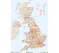
XYZ Maps UK Postcode Areas Wall Map - 100 cm x 141 cm - England, Scotland & Wales - Political Postcode Regions - 120gsm Art Paper - Ideal for Office, Classroom & Planning Use
XYZ Maps UK Postcode Areas Wall Map - 100 cm x 141 cm - England, Scotland & Wales - Political Postcode Regions - 120gsm Art Paper - Ideal for Office, Classroom & Planning Use

Cheapest Total Price
In stock
Direct debit
Direct debit
Visa
Visa
Mastercard
Mastercard
£69.99
Free Delivery
XYZ Maps UK Postcode Areas Wall Map - 100 cm x 141 cm - England, Scotland & Wales - Political Postcode Regions - 120gsm Art Paper - Ideal for Office, Classroom & Planning Use

Overall Rating: 2.4 / 5 (average from multiple review sources, as of 25 Mar 2026)
Based on a total of 46,726 customer reviews from independent review platforms.
Sources & Transparency:
The values are derived from publicly available retailer ratings from platforms such as Feefo, http://Reviews.io , Trustpilot, and others, and are aggregated monthly.
All brand names and logos are the property of their respective owners.
Notice:
pricehunter.co.uk cannot guarantee that published shop ratings originate from consumers who have actually made a purchase from the reviewed retailer.
Cheapest Total Price
In stock. Express Delivery available with Amazon Prime.
Direct debit
Direct debit
Visa
Visa
Mastercard
Mastercard
£69.99
Free Delivery
🤖 Ask ChatGPT
💡 Is it worth the price?
🔁 Better alternatives?
⭐ What do users say?
XYZ Maps UK Postcode Areas Wall Map - 100 cm x 141 cm - England, Scotland & Wales - Political Postcode Regions - 120gsm Art Paper - Ideal for Office, Classroom & Planning Use - Details
▶ Finding you the best price!
We have found 2 prices for XYZ Maps UK Postcode Areas Wall Map - 100 cm x 141 cm - England, Scotland & Wales - Political Postcode Regions - 120gsm Art Paper - Ideal for Office, Classroom & Planning Use. Our price list is completely transparent with the cheapest listed first. Additional delivery costs may apply.
XYZ Maps UK Postcode Areas Wall Map - 100 cm x 141 cm - England, Scotland & Wales - Political Postcode Regions - 120gsm Art Paper - Ideal for Office, Classroom & Planning Use - Price Information
- Cheapest price: £69.99
- The cheapest price is offered by Amazon-marketplace.co.uk. You can order the product there.
- The price range for the product XYZ Maps UK Postcode Areas Wall Map - 100 cm x 141 cm - England, Scotland & Wales - Political Postcode Regions - 120gsm Art Paper - Ideal for Office, Classroom & Planning Use is €£69.99to €£69.99 with a total of 2 offers.
- Payment methods: The online shop Amazon-marketplace.co.uk supports: Direct debit, Visa, Mastercard
- Delivery: The shortest delivery time is In stock working days offered by Amazon-marketplace.co.uk.
Similar products

XYZ Maps Scotland Postcode Areas Wall Map - Physical Map Showing UK National Postcode Regions - 700 x 880 mm - 120gsm Art Quality Paper - Ideal for Office, Planning & Education
£27.99
Amazon-marketplace.co.uk
Free Delivery
£69.99
Amazon-marketplace.co.uk
Free Delivery
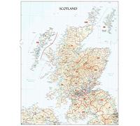
XYZ Maps Scotland Postcode Areas Wall Map - Physical Map with National UK Postcode Regions (EH) - 700 x 880 mm - Plastic Coated, Waterproof & Wipeable - Ideal for Office & Education
£29.99
Amazon-marketplace.co.uk
Free Delivery

UK White Postcode Areas Large Wall Map (AR3) - 39.5" x 55.75" Laminated
£69.99
Amazon-marketplace.co.uk
Delivery from £7.69
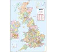
XYZ Maps UK Postcode Areas Wall Map - 100 cm x 141 cm - England, Scotland & Wales - Political Postcode Boundaries - Plastic Coated, Waterproof & Wipeable for Office & Classroom
£79.99
Amazon-marketplace.co.uk
Free Delivery
Cheapest offer
UK POSTCODE AREAS MAP: This large-format UK wall map clearly displays postcode areas across England, Scotland, and Wales. Designed for easy reference, it helps you quickly understand postcode regions, boundaries, and geographic coverage across the United Kingdom. HUGE SIZE FOR CLEAR VISIBILITY: With a generous size of 100 cm x 141 cm, this map offers excellent readability from a distance. Ideal for offices, classrooms, planning rooms, and meeting areas where large-scale postcode detail is required. DETAILED POSTCODE & REGIONAL COVERAGE: Shows clearly defined postcode areas along with political boundaries and regional divisions. A practical reference for business planning, logistics, education, territory mapping, and understanding UK postcode distribution. IDEAL FOR EDUCATIONAL & PROFESSIONAL USE: Suitable for students, teachers, planners, researchers, and professionals, this map supports geography lessons, postcode planning, exam revision, and everyday reference in academic or professional environments. ART QUALITY PAPER: Printed on high-quality 120 gsm art paper, this map delivers sharp detail and vibrant clarity. Designed for indoor wall display, it provides a clean, professional appearance suitable for long-term use.
£69.99
In stock
Amazon-marketplace.co.uk
Don't forget your voucher code:
Report Illegal Concerns
You are about to report a violation based on the EU Digital Services Act (DSA).